Good to Know
The "Japan-Problem"
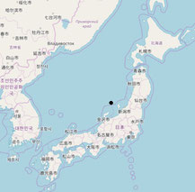
Part of the existing calculation methods, such as the "Latitude and Longitude Method," encounter their limits with the Japan problem. Therefore, the intersection of the diagonals of the enclosing rectangle for the area of Japan is in the sea. More specifically, according to our calculations, it is located north of the city of Suzu and west of Sado Island.
![Map of Japan with the midpoint of Japan marked in black. This center point was calculated based on the squaring method (minimum distance sum after dividing the country's area into [square] sub-areas).](https://image.jimcdn.com/app/cms/image/transf/dimension=217x1024:format=jpg/path/safbd4f2eea4da3ad/image/i3f13bbf1a1e38ff7/version/1715783448/map-of-japan-with-the-midpoint-of-japan-marked-in-black-this-center-point-was-calculated-based-on-the-squaring-method-minimum-distance-sum-after-dividing-the-country-s-area-into-square-sub-areas.jpg)
The squaring method provides an error-free calculation of the midpoint of any area, including Japan. By using 150 coordinate pairs from Google Maps, we were able to determine the center of Japan through the squaring method to be the city of Hakuba.
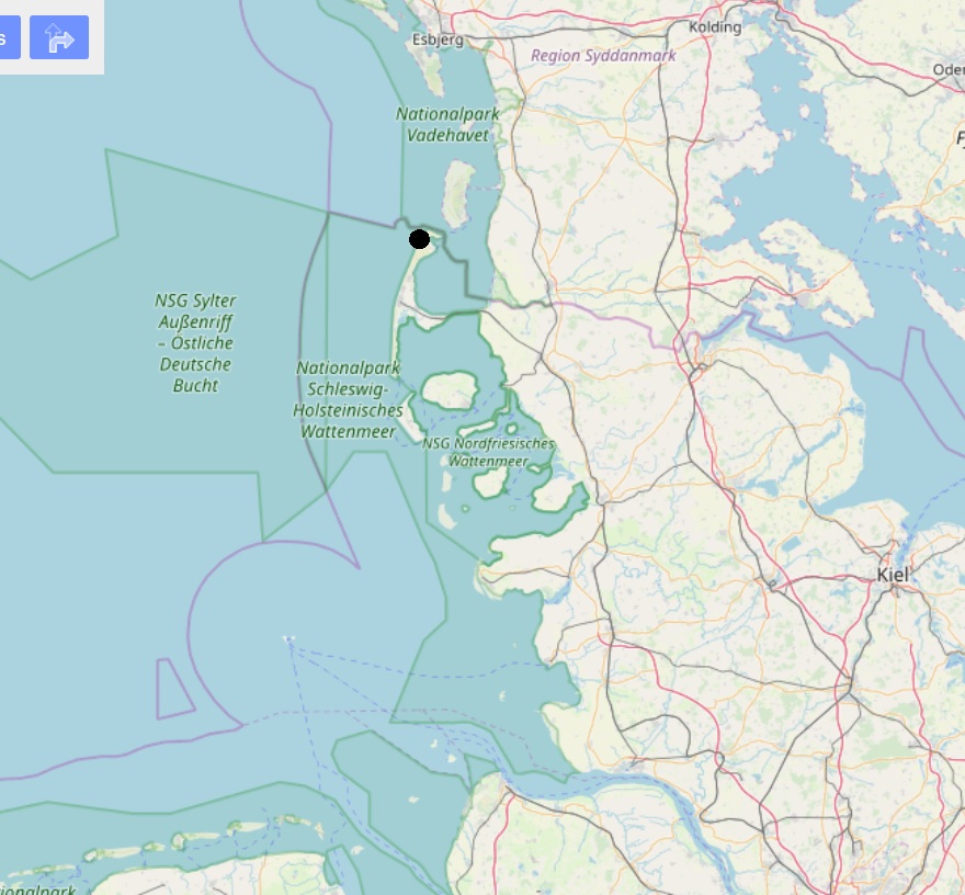
The Midpoint of Usedom
![Map of Usedom with the midpoint of Usedom marked in black. This center point was calculated based on the squaring method (minimum distance sum after dividing the country's area into [square] sub-areas).](https://image.jimcdn.com/app/cms/image/transf/dimension=303x1024:format=jpg/path/safbd4f2eea4da3ad/image/ife73acfabd68899e/version/1715783486/map-of-usedom-with-the-midpoint-of-usedom-marked-in-black-this-center-point-was-calculated-based-on-the-squaring-method-minimum-distance-sum-after-dividing-the-country-s-area-into-square-sub-areas.jpg)
The official midpoint of Usedom is located in Mellenthin, though the method used for its calculation is unknown. Based on 7,800 coordinate pairs from the Federal Agency for Cartography and Geodesy, we recalculated the midpoint of Usedom using the squaring method. The result placed the midpoint in the Odensee National Park, east of Mellenthin.
The Outermost Point of an area
In addition to the center, the squaring method can also calculate the outermost point of an area.
The midpoint always represents the point which is the most central in relation to all other square points of the area, i.e., it has the smallest total distance. The outermost point of the area is the counterpart to the center of an area. It is therefore the point that has the largest total distance. Based on our calculations (accuracy: square side length 4.26km), the outermost point of Germany is located on North Sylt.
© OpenStreetMap-Contributors